Skip to content
Corhize Logo Blanc
  • Solutions
    • Columbus®, irrigation and nutrition
    • IrrigAssistant®, irrigation recommendations
    • AspaView®, DST dedicated to asparagus production
    • Monitam®, seeding and harvest control
    • Orasa®, soil mapping
  • Services
    • Columbus Web Platform
    • Technical support
  • Company
    • Presentation of CoRHIZE
    • AquaSemence program
    • Project support
    • Quality channels
    • Our references
    • Memberships
    • Quote request
  • Resources
    • Products Seed control
    • Irrigation / Nutrition / Climate Products
    • Soil mapping
    • Let’s talk technical !
    • News
  • Contact us
Menu
  • Solutions
    • Columbus®, irrigation and nutrition
    • IrrigAssistant®, irrigation recommendations
    • AspaView®, DST dedicated to asparagus production
    • Monitam®, seeding and harvest control
    • Orasa®, soil mapping
  • Services
    • Columbus Web Platform
    • Technical support
  • Company
    • Presentation of CoRHIZE
    • AquaSemence program
    • Project support
    • Quality channels
    • Our references
    • Memberships
    • Quote request
  • Resources
    • Products Seed control
    • Irrigation / Nutrition / Climate Products
    • Soil mapping
    • Let’s talk technical !
    • News
  • Contact us
Search
Close
|
  • fr

Orasa®, soil mapping as the basis for modulation

What potentials here and there? How to get the best out of each of them?

Request a quote !
3 Ronds Blancs
Logo Corhize Orasa
Homepage
Solutions
Orasa®, soil mapping
ORASA®

Mapping of intrafield soil heterogeneity (ECa)

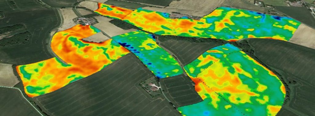
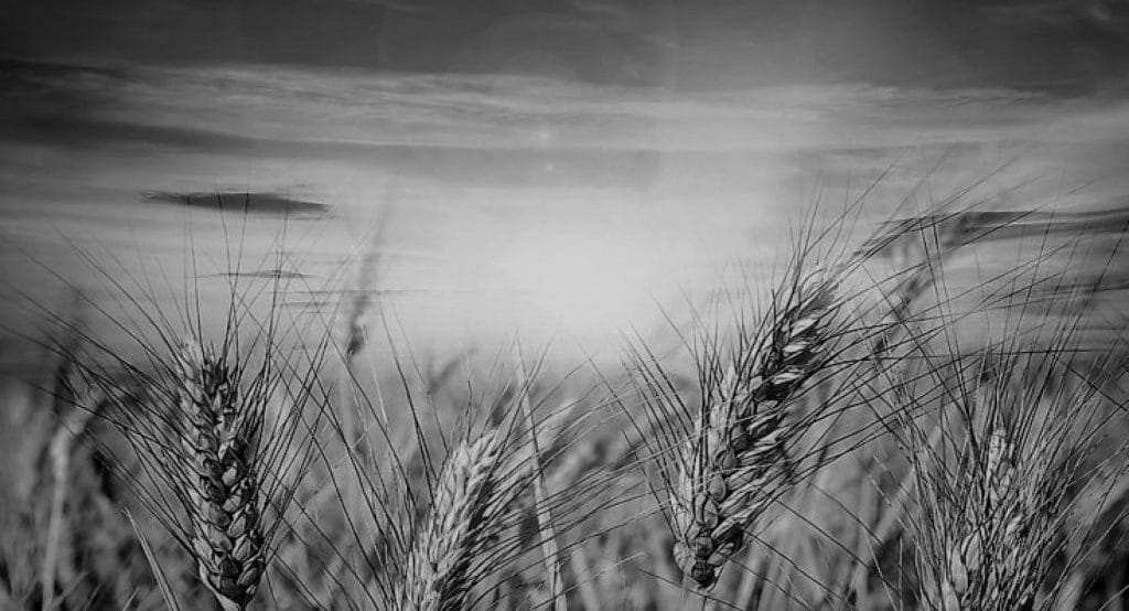
Soil mapping over several horizons is the first link in Precision Agriculture. It offers very important and multiple levers for agronomic progress.

Homme Sur Quad Pour Cartographie De Sol

Applicable to all irrigated crops

Cereals
Potatoes
Seeds
Vineyards
Orchards
Vegetables

What is Apparent Electro-Conductivity?

Corhize Cartographie De Conductivité Dans Pruniers

To map the soil, CoRHIZE uses technology based on electrical conductivity. To make simple, conductivity is the soil capability to conduct an electric pulse througt . And the higher the conductivity, the higher the clay-humic complex. The electrical conductivity is used as an indicator of the intrafield variability of the soil. It is a very reliable parameter that can be used on all types of soil. Soil mapping is a long-lasting and profitable investment.

Increase the economic performance of your plots:

Optimize your irrigation

for precise control

Modulate your inputs

according to the needs of each area

Objectives of soil mapping

Soil mapping has many applications. If its optimization involves automated modulation tools (fertilizer spreader with on-board weighing and modulation, seed drills with density modulation, pivots with dose modulation, etc.), these are not, however, compulsory in order to start developing a mapping. of ground.

Above all, soil mapping provides a better understanding of the agronomic potential of its plots. By bringing them together with historical observations in the field, it allows to ask good questions and generally provide the right answers.

TO KNOW: if vegetation maps are carried out by satellites or drones, soil maps over several depths can ONLY be carried out by specific measurement tools dragged on the ground.

Champ Avec Sillons

Learn more about soil mapping

Check out these articles to learn more about our soil mapping solution.


Corhize Illustration Cartographie De Sol Vue Densemble

Corhize’s specifics for soil mapping

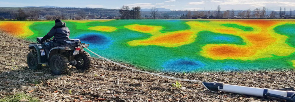
Our specifics CoRHIZE operates with its own measurement and recording equipment a lightweight, non-destructive rolling

Read more »
Illustration Pct Site

Geographical Information System "PCT"

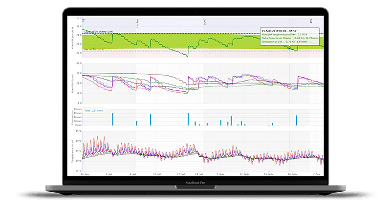
PCT, CoRHIZE’s software solution. CoRHIZE uses and represents the TerraLogga/AgGateway/AgCloud software solution of Australian Precision

Read more »

CoRHIZE specificities
for soil mapping

Benefit from CoRHIZE’s experience to successfully map your soils.


The benefits of 4 horizons

A patented technology for 4 simultaneous depths at very high resolution and centimetric GPS readings.

Restitution of maps

Mapping of the 4 horizons, multi-plot merger, zoning, height differences, placement of geolocated probes and soil samples, modulation.

Our flexibility

Our very light and non-destructive equipment allows us to work in a wide range of conditions and whatever the size of the plots.

Columbus Web Platform

Ordinateur Web Colombus
Discover Columbus

The Columbus web platform makes it possible to conveniently access data from all your agro-climatic sensors (AquaCheck capacitance probes, Nutrisens probes, weather stations, etc.).

Columbus was especially designed for irrigation management and is the benchmark today in this field.

  • Easy interpretations for quick decisions
  • Double expression of consumption in % and in mm
  • Display of individual sensor curves
  • Programmable SMS and / or email alerts
  • And many other valuable features
Need more information ?
Contact us! We will be happy to advise you!
Request a quote!
Logo Corhize

CoRHIZE sarl,
Agropole, Deltagro 3,
BP 343 ESTILLAC ,
F-47931 AGEN Cedex, FRANCE

  • +33(0)5 53 77 21 20
Facebook Linkedin Youtube
Follow us!
  • IrrigAssistant
  • AspaView
  • Solutions
  • Services
  • Company
  • Resources
Menu
  • IrrigAssistant
  • AspaView
  • Solutions
  • Services
  • Company
  • Resources
  • Contact us
  • Support access
  • Portal access
  • Privacy policy
  • Legal Notice
Menu
  • Contact us
  • Support access
  • Portal access
  • Privacy policy
  • Legal Notice
© 2020 - All rights reserved
Made by SITIXEL!
Gérer le consentement aux cookies
Nous utilisons des cookies pour optimiser notre site web et notre service.
Fonctionnel Always active
The technical storage or access is strictly necessary for the legitimate purpose of enabling the use of a specific service explicitly requested by the subscriber or user, or for the sole purpose of carrying out the transmission of a communication over an electronic communications network.
Préférences
The technical storage or access is necessary for the legitimate purpose of storing preferences that are not requested by the subscriber or user.
Statistiques
The technical storage or access that is used exclusively for statistical purposes. The technical storage or access that is used exclusively for anonymous statistical purposes. Without a subpoena, voluntary compliance on the part of your Internet Service Provider, or additional records from a third party, information stored or retrieved for this purpose alone cannot usually be used to identify you.
Marketing
The technical storage or access is required to create user profiles to send advertising, or to track the user on a website or across several websites for similar marketing purposes.
Manage options Manage services Manage vendors Read more about these purposes
Voir les préférences
{title} {title} {title}